I went on a class trip to East St Louis this weekend, and lo and behold, we visited a dome.
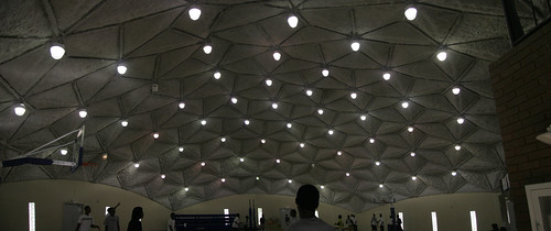
The Dome housed the gym of the Mary Brown Community Center, which was a big stop on our two day tour of the different community centers, libraries, and churches where community engagement is taking place. I was very much in awe of this dome (which didn’t seem geodesic since there weren’t just triangles, but I could be wrong). I made the spliced panorama above (hastily) while two games of pickup basketball were being played.
As a blogged about before, Domes are notorious for being difficult to maintain. I was curious about this beautiful structure so I decided to cast a net (aka Google Search) and see what info about the Mary Brown CC was out on the web.

I tried a few different search strings and eventually came across the Search Timeline for “mary brown community center”. The Timeline feature is cool, but its utility is limited. As you can see, the search results only go back as far as 1988, when Jackie Joyner Kersey began getting press about her desire to rehab the Community Center where she first began running track. The timeline displays results from the Google News database, which seems to have a limited scope. I’m sure if I went and did a similar search through old microfilm and other non-digital archives, I would come up with a much broader picture of the history of the Community Center and the Dome. Of course, I would probably never actually do that, and I was able to learn much about the Center by rifling through the results. I couldn’t find the year the Dome was built but I did learn that the Dome was rehabbed in 2004 after years of delays (and a scandal?). One thing I don’t like about this Timeline feature is that many of the News stories need to be purchased in order to view the fulltext, boo. I guess newspapers need to make money somehow.


